AIRPORT Information from Airnav.com
FAA INFORMATION EFFECTIVE 25 JUNE 2015
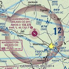
Location
| FAA Identifier: |
IIY |
| Lat/Long: |
33-46-45.9000N / 082-48-57.0000W
33-46.765000N / 082-48.950000W
33.7794167 / -82.8158333
(estimated) |
| Elevation: |
646 ft. / 196.9 m (surveyed) |
| Variation: |
03W (1985) |
| From city: |
4 miles NW of WASHINGTON, GA |
| Time zone: |
UTC -4 (UTC -5 during Standard Time) |
| Zip code: |
30673 |
Airport Operations
| Airport use: |
Open to the public |
| Sectional chart: |
ATLANTA |
| Control tower: |
no |
| ARTCC: |
ATLANTA CENTER |
| FSS: |
MACON FLIGHT SERVICE STATION |
| NOTAMs facility: |
IIY (NOTAM-D service available) |
| Attendance: |
VARIES – Please call ahead |
| Wind indicator: |
lighted |
| Segmented circle: |
yes |
| Lights: |
ACTVT MIRL RY 13/31, PAPI RYS 13 AND 31 – CTAF. |
| Beacon: |
white-green (lighted land airport)
Operates sunset to sunrise. |
Airport Communications
| CTAF/UNICOM: |
122.7 |
| WX AWOS-3: |
118.375 (706-678-3647) |
| AUGUSTA APPROACH: |
124.45 |
| AUGUSTA DEPARTURE: |
124.45 |
| WX AWOS-3 at EBA (19 nm N): |
118.15 (706-283-8133) |
| WX AWOS-3 at CPP (19 nm SW): |
124.525 (706-453-0017) |
- APCH/DEP SVC PRVDD BY AUGUSTA APPROACH CONTOL 0645-2300 ON FREQS 124.45/270.3 OTHER TIMES BY ATLANTA ARTCC ON FREQS 128.1/322.325 (AUGUSTA RCAG).
Nearby radio navigation aids
| VOR radial/distance |
|
VOR name |
|
Freq |
|
Var |
| AHNr112/27.3 |
|
ATHENS VORTAC |
|
109.60 |
|
00E |
| IRQr282/32.9 |
|
COLLIERS VORTAC |
|
113.90 |
|
04W |
| ELWr182/38.4 |
|
ELECTRIC CITY VORTAC |
|
108.60 |
|
00E |
| NDB name |
|
Hdg/Dist |
|
Freq |
|
Var |
|
ID |
|
|
|
|
|
|
|
|
|
|
| JUNNE |
|
057/13.0 |
|
353 |
|
05W |
|
VV |
…- …- |
| BULLDOG |
|
120/22.6 |
|
221 |
|
03W |
|
BJT |
-… .— – |
| COMMERCE |
|
119/39.0 |
|
244 |
|
03W |
|
DDA |
-.. -.. .- |
| BARROW COUNTY |
|
109/39.7 |
|
404 |
|
05W |
|
BMW |
-… — .– |
Airport Services
| Fuel available: |
100LL JET-A |
| Parking: |
hangars and tiedowns |
| Airframe service: |
NONE |
| Powerplant service: |
NONE |
| Bottled oxygen: |
NONE |
| Bulk oxygen: |
NONE |
Runway Information
Runway 13/31
| Dimensions: |
5020 x 75 ft |
| Surface: |
asphalt, in excellent condition |
| Weight bearing capacity: |
|
| Runway edge lights: |
medium intensity |
|
RUNWAY 13 |
|
RUNWAY 31 |
| Latitude: |
33-46.958803N |
|
33-46.569728N |
| Longitude: |
082-49.271037W |
|
082-48.628410W |
| Elevation: |
645.7 ft. |
|
632.0 ft. |
| Gradient: |
0.3% DOWN |
|
0.3% UP |
| Traffic pattern: |
left |
|
left |
| Runway heading: |
129 magnetic, 126 true |
|
309 magnetic, 306 true |
| Markings: |
nonprecision, in fair condition |
|
nonprecision, in fair condition |
| Visual slope indicator: |
2-light PAPI on left (3.00 degrees glide path) |
|
2-light PAPI on left (3.00 degrees glide path) |
| Touchdown point: |
yes, no lights |
|
yes, no lights |
| Obstructions: |
58 ft. trees, 2172 ft. from runway, 417 ft. right of centerline, 34:1 slope to clear |
|
20 ft. trees, 640 ft. from runway, 297 ft. left of centerline, 22:1 slope to clear |
Airport Ownership and Management from official FAA records
| Ownership: |
Publicly-owned |
| Owner: |
WILKES COUNTY
23 COURT STREET, ROOM 222
WASHINGTON, GA 30673
Phone 706-678-2511 |
| Manager: |
Dann Standard
351 AIRPORT ROAD
WASHINGTON, GA 30673
Phone 706-836-0442 |
Airport Operational Statistics
| Aircraft based on the field: |
|
21 |
| Single engine airplanes: |
|
17 |
| Multi engine airplanes: |
|
1 |
| Ultralights: |
|
3 |
|
|
 |
|
| Aircraft operations: avg 115/week * |
| 50% |
transient general aviation |
| 50% |
local general aviation |
|